geontp
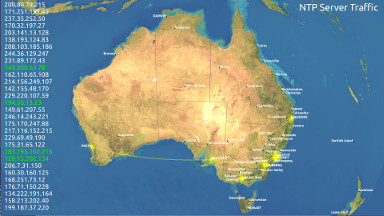
geontp displays live NTP traffic information geographically - the locations of NTP requests from clients are shown with an animated sparkly graphic and an arc is drawn connecting the client to the server. This is of course only possible if you have a database of NTP client IPs and their locations. How you make this database is up to you.
Some of geontp's features are:
- The agent uses a packet sniffer to collect client data which is then sent back to geontp when it makes a custom HTTP request. Bandwidth usage is minimised - each client is described by only 8 bytes.
- Displays a scrolling list of client IPs (these can be anonymised).
- There's a configuration file that allows you to play with many settings.
- It can power down the display at programmed times to save power and the monitor.
Note that the very nice map you see in the screenshot above is not supplied with geontp since it is a commercial image (available from L3Harris) and cannot be freely distributed. Instead, I have included part of a free NASA image.
If you find a bug let me know.
Download geontp source code here. There are some instructions and setup hints in the README. You guessed it, no binaries.
